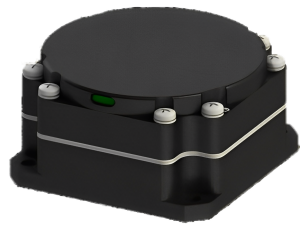
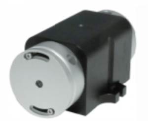
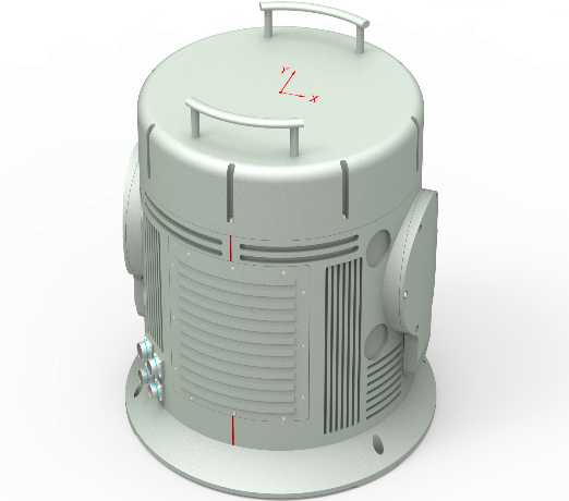
RLG Two-Axis Indexing Inertial Navigation System
Product description
RL2-90 Inertial Navigation System, a cutting-edge solution for precise navigation. Equipped with a type 90 ring laser gyroscope and quartz flexible accelerometer, it provides accurate speed, position, and attitude information. It seamlessly integrates with GNSS, altimeters, and airspeed meters, making it suitable for air and ground carriers. Whether in tanks, armored vehicles, aircraft, drones, ships, or high-speed rail, this system ensures reliable flight control, attitude stabilization, and positioning. With high accuracy in both pure inertial navigation and integrated navigation modes, the RL2-90 is your trusted partner for dependable and precise navigation in various applications.
PRODUCT FEATURES
l Two-axis indexing mechanism for error mitigation
l High accuracy ring laser gyro and quartz accelerometer
l Optional static or moving base self-alignment
l Error parameters calibration and compensation in full temperature range
l Optional diverse input interfaces for GNSS/Odometer/DVL
l Configurable navigation modes
l Excellent environmental suitability
l Military standards
APPLICATION AREAS
l Under-sea vehicle navigation
l Positioning and north-finding for land vehicle
l Stabilization and control for moving carrier
l Attitude measurement for demanding applications
MAIN FUNCTIONS
l It has the function of outputting information such as carrier position, heading, attitude angle, angular rate and speed in real time;
l It has working modes such as pure inertial navigation and INS/GNSS (including Beidou) integrated navigation;
l Possess the function of receiving satellite navigation information provided by external time system frequency standard equipment;
l It has the function of ground self-alignment and supports the function of air alignment;
l It has functions such as power-on self-test, periodic self-test, status report, installation error compensation, and non-volatile storage.
PERFORMANCE INDICATORS
|
System accuracy System Accuracy |
Pure Inertial Navigation/Pure Inertial Navigation |
2.0nmile/5d, PEAK |
|
|
Integrated Navigation/Navigation with GNSS |
≤5m , 1σ |
||
|
Heading angle /Heading |
0.01°, RMS |
||
|
Horizontal attitude (roll and pitch ) Horizontal Attitude (roll & pitch) |
0.005°, RMS |
||
|
Pure Inertial Velocity |
1.0 m/s , RMS |
||
|
GNSS Integrated navigation Velocity |
0. 1 m/s , RMS |
||
|
Indicators of inertial devices Gyro and Accelerometer Parameters |
laser gyroscope _ Gyroscope |
Range/Range |
± 6 00 deg/s |
|
Bias Stability |
≤0.002 deg/h, 1σ |
||
|
Bias Repeatability |
≤0.002 deg/h, 1σ |
||
|
Scale Factor non-linearity |
1 ppm |
||
|
Accelerometer Accelerometer |
Range/Range |
± 15g |
|
|
Bias Stability |
≤10μg , 1σ |
||
|
Zero bias repeatability Bias Repeatability |
≤10μg , 1σ |
||
|
Scale Factor non-linearity |
15 ppm |
||
|
align time Alignment Time |
Cold Start |
≤ 15 min |
|
|
Re-Start |
≤ 10 min |
||
|
Air/In-Flight Start |
≤15min |
||
|
Working hours Operation Time |
Continuous working time/Operation Time |
more than 10h |
|
|
Interface Features interface |
Supply voltage/Voltage |
18~36VDC |
|
|
Power Consumption |
≤ 40W @ 24VDC |
||
|
Electrical interface/Electrical |
RS232 × 2 RS422 × 3 CAN × 2 Ethernet × 1 1pps × 1 |
||
|
Data Update Rate (configurable) |
200Hz@115.2kbps |
||
|
Use environment Environmental |
Operating Temperature |
-40°C~+65°C |
|
|
Storage temperature/Storage Temperature |
-55°C~+85°C |
||
|
Use Altitude/Altitude |
20000m |
||
|
Humidity |
95% (+25°C) |
||
|
Vibration/Vibration |
5g @ 20~2000Hz |
||
|
Shock/Shock |
40 g, 11 ms, 1/2 Sine |
||
|
Physical properties Physical |
Dimensions/ Size (Φ*H) |
540 x 536mm |
|
|
Weight/ Weight |
55 kg |
||
Note: The structure can be customized according to the user’s requirements.